Typical first-workflow build, full source transfer at handoff
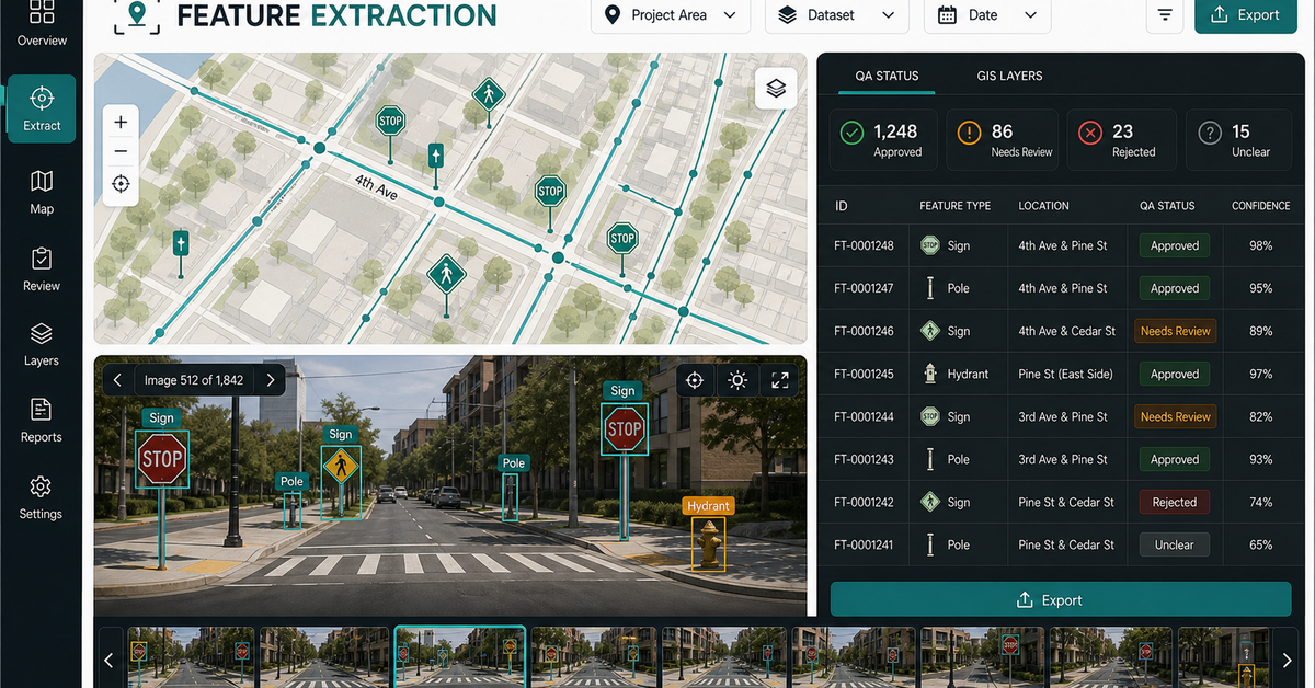
ArcGIS Workflow Automation
Python and arcpy scripts that run geoprocessing, publishing, and data sync on a schedule — with validation and exception handling in scope.
We automate spatial workflows for municipalities, utilities, and infrastructure teams — asset inventory, survey processing, and data pipelines with QA and runbooks.
Typical first-workflow build, full source transfer at handoff
Python and arcpy scripts that run geoprocessing, publishing, and data sync on a schedule — with validation and exception handling in scope.
Automated asset import, validation, and updating from field data, CAD, and survey sources.
Scheduled ETL from field apps, GPS devices, and third-party APIs into your GIS of record.
Documented workflows with topology checks, attribute validation, and runbooks so the system doesn't depend on one analyst.
Maps, statistics, and change detection delivered to stakeholders automatically — no analyst in the loop.
Municipal GIS automation, utility GIS automation, and asset inventory automation.
Keep inspections, source photos, map records, and QA status tied together.
Flag missing attributes, duplicates, poor geometry, and records that need human review.
Reports, dashboards, export layers, and review packets generated on cadence.
Modeled on the live Geospatial Solutions demos: the page should show what the buyer sends, what they review, what evidence stays visible, and what they receive.
Asset layers, inspection tables, sign inventories, field submissions, GIS databases, and manual review steps.
Automation creates the queue, flags records that need review, and preserves source context.
Each output keeps validation status, exception reason, source record, and reviewer state visible.
Scheduled report, dashboard, feature layer, CSV, GeoJSON, or runbook.
Automation should leave a visible review state for records that need human attention.
Public-sector workflows often need source and limitation notes preserved.
Asset layers, inspection tables, sign inventories, field submissions, GIS databases.
Automated checks plus manual review queues and correction logs.
Scheduled report, dashboard, feature layer, CSV, GeoJSON, or runbook.
No vague discovery phase. You bring four or five things, we return a specific plan you can evaluate.
Structured logging on every step. When something fails, your on-call knows what failed and why before they open the runbook.
[2024-08-15 14:23:08] INFO pipeline.survey123_sync start
[2024-08-15 14:23:08] INFO fetch.survey123 form_id=da472a records=14302 elapsed=412ms
[2024-08-15 14:23:09] INFO validate.schema passed=14302 failed=0
[2024-08-15 14:23:11] INFO geometry.buffer features=14302 radius=500m elapsed=2.1s
[2024-08-15 14:23:14] INFO spatial.join layer=parcels result=27894 elapsed=3.2s
[2024-08-15 14:23:17] INFO publish.arcgis_online service=ParcelsBuffered version=v847 elapsed=2.8s
[2024-08-15 14:23:17] INFO pipeline.survey123_sync complete duration=9.2s next_run=2024-08-16T02:00:00Z
No open-ended retainers. No "discovery phases" that bill for months without producing anything you can evaluate.
We shadow your team for a week — watch the workflows, catalog the pain points, and rank automation candidates by hours saved per quarter.
First workflow in 2-4 weeks. Python or TypeScript, with validation, exception handling, and structured logging from day one.
30 days in production with us on call. We catch the edge cases, tighten the validation, and document the failure modes.
Runbook, infrastructure-as-code (Docker or serverless), and full source. Your next analyst can read it without reverse-engineering.
These open the real, interactive demos on our main site — not screenshots, not videos. Click around before you decide to talk to us.
No. Most of our utility clients are 50-500 staff. We size the automation to your team — a 200-staff municipality doesn't need a Kubernetes cluster, just a scheduled Python script with logging and a runbook.
Yes. We deploy into your environment, respect your security boundary, and integrate with your existing ArcGIS Enterprise identity model. No data leaves your firewall unless you choose to send it.
Most clients see payback in 4-9 months on the first workflow. Subsequent workflows reuse the framework, so payback shrinks. We share the ROI math during scoping so you can validate independently.
Yes. Many engagements include a 'shadow build' phase where your team builds alongside us, learning the patterns. By month 3 most teams can scope and build new workflows independently.
From raw survey data to published web maps — we package joins, buffers, routing, and imagery into controlled w…
Dispatch optimization, container tracking, and demand prediction built for roll-off dumpster companies — runni…
We turn inspections, asset inventories, environmental sampling, construction checks, and field surveys into mo…
Anchored in the NAIPAI pattern: ask aerial, drone, or satellite imagery useful questions, keep confidence and …
Bring the workflow that takes the longest every week. We will scope an automation candidate with effort estimates and a written delivery plan within 48 hours.
Automate one municipal GIS workflow